|
|---|
Saturday, July 30, 2011
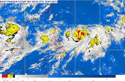
At 11:00 a.m. today, Tropical Storm "KABAYAN" has slightly intensified as it moves Northward.
Tropical Storm "Kabayan" is estimated based on satellite and surface data at 930 km East Northeast of Virac, Catanduanes (16.2°N, 133.6°E) with maximum sustained winds of 95 kph near the center and gustiness of up to 120 kph.
Philippine Atmospheric, Geophysical and Astronomical Services Administration (PAGASA) said that Tropical Storm "Juaning" is moving North at 15 kph.
WEATHER FORECAST
Sunday morning: 1,1130 km East of Aparri, Cagayan
Monday morning: 1,090 km East Northeast of Basco, Batanes
Tuesday morning: 960 km Northeast of Basco, Batanes or at 400 km Southeast of Okinawa, Japan
PUBLIC STORM WARNING SIGNAL
No storm warning signal raised
Estimated rainfall amount is from 15 - 25 mm per hour within the 650 km diameter of the storm. This weather disturbance is too far to directly affect any part of the country. Bataan, Zambales and Pangasinan will continue to experience monsoon rains (moderate to heavy) which may trigger flashfloods and landslides
0 Comments:
Subscribe to:
Post Comments (Atom)


